Geographical Location and Historical Formation Lake Qarun is a natural reservoir of significant environmental, historical, and economic importance.
Lake Qarun is located in the northwestern part of the Wadi El Rayan depression in the Fayoum Governorate, within the Fayoum Oasis region.
It is one of the largest natural inland lakes in Egypt.
Its current area is estimated at approximately 138 km² (after historical reductions).
It is indirectly connected to the Nile River via the Wadi Drain, and its primary source of water is agricultural drainage. Lake Qarun is located in the northwestern part of the Wadi El Rayan Depression in the Fayoum Governorate, within the Fayoum Oasis region.
It is believed to be the remnant of a larger, ancient lake known as Lake Moeris, which was managed by the pharaohs as a water system for irrigation and flooding.
The lake's surface lies approximately 43 to 45 meters below sea level (low relative to sea level) in most parts.
The lake's area is estimated at approximately 55,000 acres.
Environmental Characteristics Depth: The lake's depth ranges from approximately 5 to 12 meters.
Water Level: Approximately 45 meters below sea level in most parts.
Salinity: Relatively high salinity, ranging from 32 to 35 grams of salt per liter of water.
The Qarun Fishermen's Cooperative is located there.
The nature of the water in the pond: Its water was originally fresh, but it has become brackish to saline due to the accumulation of salts from agricultural runoff.
The water's salinity increases gradually from east to west.
It is characterized by its biodiversity, but it has been greatly affected by pollution and increased salinity.
Hydrological and Hydraulic Characteristics Lake depth: For example, the maximum depth is reported to be “only above 8 m” in some areas. High salinity: The lake's water inflow is primarily from agricultural and domestic drainage, and significant evaporation leads to salt concentration. For example, the salinity level has been reported to have increased from approximately 11‰ g/L in the early 20th century to approximately 34–39‰ later.
Water source: It was mentioned that the lake is primarily fed by the Al-Battas and Al-Wadi drains, in addition to 12 smaller drains.
Being a nearly "closed" lake (with no effective natural outlet) increases sedimentation and salinity.
Types of farmed fish found in the pond
Due to the salty nature of the water, the pond contains types of fish that tolerate salinity:
Lake Nasser
Lake Nasser is a large artificial reservoir formed after the construction of the Aswan High Dam. The lake began filling in 1964. The Egyptian portion is known as Lake Nasser, while the Sudanese portion is known as Lake Nubia.
It includes associations such as: 1. The Aswan Fishermen's Cooperative (Mother) 2. The Nubian Fishermen's Cooperative in Aswan 3. The Aswan Governorate Fishermen's Cooperative 4. The Integrated Cooperative for Fishermen in the villages of Qastal and Adindan, Aswan
Area Approximately 6,216 km² in total, of which ~5,248 km² are within Egypt.
Depth The depth ranges to approximately 180 meters in some areas.
The shores and creeks (khors) The lake contains approximately 85 creeks (wadis), the most important of which are Khor Tishka, Khor Kalabsha, Khor Al-Allaqi, and others. These creeks are characterized by shallow waters and form suitable environments for the breeding and feeding of aquatic life.
Water level fluctuations There are seasonal and annual variations in water level, which affect the activity of fisheries as well as the shallow creeks.
Fisheries and Species
Annual Production Production varies – depending on the year – between approximately 25,000 and 30,000 tons in good seasons. For example, in 2020, production was around 25,100 tons.
Main species: - Nile tilapia and other tilapia species (Tilapia spp.).
- Nile perch.
- Predatory fish such as Hydrocynus (e.g., tigerfish).
- Species such as Alestes spp. and Barbus spp.
- A total of approximately 57 species have been recorded in the lake.
Fishing Styles and Tools
• Shallow creeks are used with tools such as trammel nets and shore fishing.
• In open water, gill nets and longlines are used.
• There are many boats (over 3,000 by some estimates) and hundreds or thousands of fishermen operating on the lake.
Economic and social importance Lake Nasser provides an important source of fish for the food of the population in Upper Egypt (Aswan Governorate and surrounding areas), and also exports a portion of its products or transports them to Cairo and the markets of northern Egypt.
Nile River
The Nile River is the world ' s longest river (about 650 km) and passes in 11 African States, from the Viktoria lake and others) to the Mediterranean.
Location Lake Edku is located in the Beheira Governorate, northern Egypt, on the Mediterranean coast.
The lake is one of the lakes of the northern coast and the Nile Delta, and is related to the ancient Canopic branch of the Nile (according to some sources).
The Badko Fishermen's Cooperative is located there.
Area and Historical Development of the Water Body
In the 20th century, the area was reported to be approximately 52,000 acres (as you mentioned).
Later, it was suggested that the area had shrunk to approximately 19,000–20,000 acres by the mid-to-late 20th century (e.g., in an environmental document: “approximately 19,000–20,000 acres”).
A more recent study suggests that the area may have shrunk to approximately 14,000–15,000 acres, which is consistent with the previously mentioned figure of “shrinking to approximately 14,000–15,000 acres.”
Some other sources give a different acreage figure.
For example, one news report states that the lake's total area is 31,876.6 acres, divided between open fishing areas, fish farms, and reed beds.
What's important: There's a clear decrease in area due to land reclamation, encroachments, vegetation cover, and sedimentation.
Environmental and Hydrological Characteristics The lake is connected to the Mediterranean Sea via the Al-Ma'adiya Strait, and receives some brackish (or slightly brackish) water depending on the condition of the strait.
It also receives water from agricultural drainage, industrial wastewater, and domestic wastewater from the surrounding villages, and is part of the Nile Delta. The lake discharges water from agricultural drainage canals—see document:The water consists of approximately 90% agricultural drainage + 10% seawater via the strait.
The lake's depth was very low at times (less than one meter in some areas) due to sediment and vegetation accumulation and limited water drainage.
The lake is connected to the Mediterranean Sea via a passage called the "Bougaz El-Maadia" or "El-Maadia" strait. This passage allows seawater to enter or exit depending on the tides and hydraulic pressure.
For example, one report states that the lake receives approximately 1.738 billion cubic meters of wastewater annually.Regarding salinity:Due to increased freshwater and wastewater discharge, the lake's salinity has decreased to the point where it is now brackish or even less saline than marine conditions.Furthermore, the lake suffers from siltation and the growth of aquatic weeds (reeds, river hyacinth, and submerged plants), which reduces its actual depth and restricts water movement and renewal.
Lake Burullus
Location, area, and general characteristics
Lake Burullus is located in Kafr El Sheikh Governorate, in the northern Nile Delta near the Mediterranean Sea—almost entirely within the governorate.
It is the second largest natural lake in Egypt in terms of area.
Estimates of its area vary depending on the source: it is approximately 460 square kilometers, or roughly 110,000 acres.
The lake is approximately 70 km long and between 6 and 17 km wide.
The lake is connected to:
The waters of the Nile River via the Barmbal Canal.
The Mediterranean Sea via the Burullus Strait.
The lake contains several natural islands, which are a source of plants and birds and a rich environment.
Legal and administrative status
It was declared a nature reserve by official decree in 1998.
It was declared a nature reserve by Decree No. 1444 of 1998 with the aim of protecting the biodiversity and ecological balance of the lake.
It is currently under the supervision of the Environmental Affairs Agency in cooperation with the Agency for the Protection and Development of Lakes and Fisheries.
Environmental analysis using SWOT for cooperative associations of fishermen in Lake Burullus in Kafr El Sheikh Governorate. The study included seven associations:
1. Burullus Fishermen's Association
2. Minya Al-Morshed Fishermen's Association
3. Al-Shakhlouba Fishermen's Association
4. Barbal Fishermen's Association
5. Baltim Fishermen's Association
6. Emad Bahri Fishermen's Association
7. Al-Maqsaba and Mashtouha Fishermen's Association
The importance of Lake Burullus in food security
It is one of the main sources of fish wealth in Egypt.
It supplies local markets in Kafr El Sheikh, the Delta, and Greater Cairo.
It contributes to reducing pressure on marine production and industrial fish farms.
It is connected to the Nile River via the Barmbal Canal and to the Mediterranean Sea via the Burullus Strait. The lake is approximately 6 to 17 kilometers wide.
Lake Manzala
Lake Manzala, the largest freshwater lake, was ordered by President Sisi to be developed in 2019 to become a global tourist destination.
The Egyptian state has launched several major development projects that have contributed significantly to the advancement of the Egyptian economy in the coming years. The Egyptian Lakes Development Project was one of the mega national projects to complete the real development process that President Abdel Fattah El-Sisi began by issuing his directives to develop the lakes, solve the obstacles and problems they face, and restore them to their former glory, even turning them into world-class lakes.
During the inauguration of a number of projects in Damietta Governorate, and while listening to the latest developments in the development and improvement of Lake Manzala, President Abdel Fattah El-Sisi emphasized the need for the lake, after its development and improvement, to comply with international standards, such as those of lakes in developed countries.
Lake Manzala is one of the most important lakes in Egypt, overlooking four governorates, namely Dakahlia, Damietta, Port Said, and Sharqia. It is located north of Dakahlia Governorate, and the presence of the lake in this area has led to the growth of many crafts related to fishing in the lake.
The crafts of wooden boat building, fishing net manufacturing, ice production, speedboat engine repair, fish trading, and market distribution have spread throughout the region, making it famous for these fishing-related crafts.
The president instructed the Ministry of Environment to review factories that dispose of industrial waste in lakes, and instructed the Ministry of Agriculture to provide fish fry to be released into the lake after the completion of development, dredging, and deepening operations. He also directed the Ministry of Housing to build suitable housing for fishermen working on the lake to prevent any encroachment on it, noting that the lake's development began in 2019 and was completed by 2021, making it a global tourist destination.
Alaa Farouk, Minister of Agriculture and Land Reclamation, said that the ministry, through the Lake Development Authority, in cooperation with other relevant authorities, is undertaking efforts to develop Lake Manzala, which included cleaning up and removing encroachments, and dredging, given the lake's important role in meeting the local market's demand for fish, especially tilapia.
Suez Canal
First: Definition of fish farming
Fish farming is the breeding of various species of fish and marine organisms in artificial or semi-natural environments such as earthen or concrete ponds or marine cages, for the purpose of food production, export, or restocking.
Second: Project location (Suez Canal)
The Suez Canal Authority's fish farming project is located on both banks of the New Suez Canal, particularly in the Ismailia and North Sinai regions, and is one of the largest fish farming projects in the Middle East.
Third: Components of the Suez Canal fish farming project
1. Number and size of ponds
The project includes more than 4,000 fish ponds.
Each pond covers an area of approximately 1.75 acres.
2. Types of ponds
Earthen ponds for semi-intensive farming.
Concrete ponds for intensive farming.
Hatching ponds for breeding fry.
Recirculating aquaculture systems (RAS), which are advanced systems.
3. Other units and facilities
Advanced laboratories for water and soil analysis.
Feed mills specific to the project.
Training and rehabilitation units.
Fish sorting and packaging areas.
Fourth: Species farmed in the Suez Canal
Nile tilapia and red tilapia
Sea bream and sea bass Sea bass
Mullet
Shrimp
Eels
Marine fish farming experiments
Fifth: Economic and environmental benefits of the project.
✅ Economic:
Reducing the fish import bill.
Providing thousands of direct and indirect job opportunities.
Supporting exports to Arab and European markets.
Developing the Suez Canal axis.
✅ Environmental:
Use of calculated and purified water.
Water recycling in some systems.
No Image
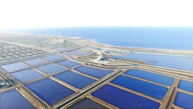
The Turquoise Fish Farming Project
Location and size:
The project is located east of Tafreya, Port Said Governorate, on the Mediterranean coast.
Its total area is approximately 26,000 acres.
It faces the coast for about 17 km and extends about 10 km inland.
Key components:
The project includes 5,908 fish farming ponds.
Each pond covers an area of approximately 1.75 acres.
Expected annual production capacity exceeds 13,000 tons of fish and shrimp.
Infrastructure and services:
Turquoise Lakes for sea fishing: A total of approximately 10,000 acres are designated for sea fishing.
East Turquoise Lake ~ 425 acres.
West Turquoise Lake ~ 5,772 acres.
Sedimentation ponds ~ 3,565 acres used for water sedimentation and drainage and final water treatment.
A shipyard 120 meters long and 80 meters wide, capable of accommodating about 6 fishing vessels up to 30 meters in length.
Logistics area to support fish cages in the Mediterranean Sea, including:
Storage refrigerators.
Net storage yard.
Feed storage.
Fish and shrimp sorting and packaging plant, with research laboratories to test water and soil quality, feed suitability, and fish health safety.
Objectives and benefits:
One of the largest fish farming projects in the Middle East.
Providing many job opportunities, estimated at approximately 10,000 direct and indirect jobs.
Reducing fish imports, achieving self-sufficiency in some fish species, and opening up export opportunities.
Supporting the economic and investment development of the Suez Canal and Sinai regions.
Establishment of the “Baraka Ghalyoun ” fish farms in Kafr El Sheikh Governorate
The national fish farming project in Kafr El Sheikh, “Baraka Ghalyoun,” is one of the most important national projects launched by President Abdel Fattah El-Sisi. It is the first of its kind in the Middle East and Africa, contributing to bridging the food gap and supporting the national economy by relying on the latest scientific and technological means in fish farming and manufacturing, which are in line with modern scientific requirements. This project will increase Egypt's fish wealth by 75%, enabling it to meet the needs of the local market and export the surplus to provide hard currency.
This project, implemented by the Armed Forces through the National Company for Fish Farming and Aquaculture, to transform this area stretching along the coast for more than 20,000 acres, which was known as an “illegal immigration area,” into a distinguished fish production area for domestic and foreign markets, providing employment opportunities for more than 15,000 citizens, 5,000 direct jobs, and more than 10,000 variable jobs.
The entire project is considered environmentally friendly, as the fish farm's water is purified through the establishment of water purification treatment units, both before farming and after fish extraction, based on scientific principles to preserve the environment surrounding the farm.
Project stages:
Work began on the construction of the Ghalyoun Industrial Fish City in Kafr El Sheikh Governorate in July 2015 with the signing of a contract with Evergreen , a company specializing in fish farming in the People's Republic of China. One of the most important provisions of the contract was to benefit from their experience in managing and operating factories and preparing engineering studies for the project through a distinguished consulting office with the help of professors from Kafr El Sheikh and Alexandria Universities and in cooperation with the General Authority for the Development of the
Tilapia is less abundant due to high salinity; red tilapia is sometimes found.
Sea bass is a marine species being farmed.
Sea bream is farmed in cages or ponds.
Shrimp farming is currently underway.
Fish eels (deer) used to exist naturally, but they have almost become extinct from the pond.
Fish farming patterns in the region: Natural farming (open fishing) via fishing boats in different areas of the pond.
Fish farming in cages: Experiments are being conducted on raising marine species such as sea bass and gilthead bream within the pond.
Open-air fish farms around the pond: There are private and community-run farms that use pond water or drainage water for fish farming.
Government projects (affiliated with the Fisheries Authority) A number of official farms spread around the banks of the pond.
A nature reserve since 1989. The lake is an important destination for migratory and resident birds, due to its being a rich water center in a semi-arid desert surrounding area.
Also, there are important geological and archaeological sites: such as Jabal Qatrani, mammal fossils, some of which are millions of years old, some petrified trees, and Pharaonic and Roman archaeological sites.
Biodiversity, Ecology, and Archaeology
An important area for migratory and resident birds: it is a popular birdwatching destination.
Vegetation: Halophytic/semi-halophytic plants are found on the edges, along with some desert plants, such as Tamarix nilotica and Nitraria retusa.
Ancient Archaeology and Geography: The area boasts significant geological and physiological sites (e.g., ancient mammal fossils, petrified plants), in addition to Pharaonic and Roman archaeological sites.
Nature Reserve: It has been declared a protected area under the supervision of the relevant environmental authority.
Development efforts and projects The governorate began taking steps to restore the lake's ecological balance several years ago, even though the procedures were costly and difficult.
There is news from the governor of Fayoum that the state has begun work to improve the environmental situation, reduce salinity, eliminate parasites, and possibly improve the surrounding agricultural drainage.
State efforts to develop Lake Qarun:
1. Lake Development and Cleaning Project: Removing sediment and encroachments to improve water quality.
2. Agricultural Drainage Development: Reducing pollution entering the lake.
3. Increasing fish fry stock: Through the General Authority for Fish Resources' hatcheries to stock tilapia and mullet.
4. Marine Aquaculture Projects Expanding sea bass and gilthead bream farming using intensive systems.
5. Monitoring Fishing Periods Imposing biological rest periods to protect fish stocks.
Economic Importance
Provides employment opportunities for hundreds of fishermen in Fayoum.
Important source of fish for the governorate and Upper Egypt. A base for marine aquaculture experiments in inland waters. Supports related industries (packaging, transportation, sales).
The Future of Aquaculture in Lake Qarun:
The trend towards using intensive aquaculture systems (RAS) outside the lake to reduce reliance on its water.
Establishing marine hatcheries to provide saltwater fish fry.
Studying the feasibility of partial desalination in some areas of the lake to expand fish diversity. Expanding integrated aquaculture around the lake (farming + fish).
Economic and Social Activities
Fishing: The lake was once an important source of fish, and the surrounding communities relied on fishing for their livelihood. However, production has declined significantly. For example, it was reported that production fell to 873 tons in 2016, compared to 4,522 tons in 2014.
Agriculture and Surrounding Farms: Drainage from agricultural lands enters the lake, linking the agricultural economy to the aquatic environment.
Tourism and related activities: The site is geared towards attracting nature/desert tourism (birdwatching, sand, deserts).
Proposed Reform and Management Efforts
Projects include salinity reduction, improved drainage, and environmental monitoring.
Increased focus on sustainable ecotourism and developing infrastructure to support local fishermen is proposed.
Wastewater treatment and the creation of natural channels or outlets for the lake can also help alleviate pressure.
Continued Environmental Monitoring:Analysis of heavy metals, water quality, biodiversity, fish stocks, changes in salinity and depth.
In-depth and up-to-date information In an economic study entitled “The Economic Dimension to the Production of Fish, Lake Qarun in Fayoum Governorate”, it was mentioned that the salinity of the lake increased from 32.45‰ in 2015 to about 34.3‰ in 2016, and this led to a decrease in fish production and a decline in species diversity.
A study entitled “Different Pollutant Monitoring in Qarun Lake” conducted by Cairo University and Al-Azhar University and published in 2018 indicated the presence of heavy metal pollution in the lake: for example, Cd- was measured at 0.0034 mg/L, Zn at 1.091 mg/L, NH₃ at 0.58 mg/L, and PO₄³⁻ at 1.38 mg/L.
In the study “Studying of Physico-chemical and Biological Characters of Qarun Lake, El-Fayoum – Egypt” (2017), water analysis was monitored monthly for a year (May 2015 – April 2016). The study reported that the lake contains 89 species of phytoplankton, distributed across 6 classifications: Bacillariophyceae (39 species) > Cyanophyceae (18) > Chlorophyceae (10) > Euglenophyceae (10) > Dinophyceae (9) > Cryptophyceae (3).
A study analyzing land use/land cover changes and their impact on the lake's water quality, published in 2025 under the title "Evaluating the Impact of Land Use Changes on Water Quality in Lake Qarun, Egypt, Using Remote Sensing and GIS-Based Water Quality Index Modeling," yielded the following results: The lake's Water Quality Index (WQI) was calculated and found to range from 84.33 to 305.53—values indicating that the water quality is almost "unsuitable" for aquatic organisms.
Another study on “Heavy Metal Pollution Indices” in the lake's waters (2020) showed that the highest concentrations of some metals were: Fe at 587.55 µg/L, Mn at 59.6 µg/L, Zn at 61.92 µg/L, Ni at 50.72 µg/L, and Cd at 3.63 µg/L. The study concluded that the lake “suffers from severe heavy metal pollution,” which threatens its aquatic life.
A long-term analysis study (2016) entitled “Long-term changes of physicochemical parameters and benthos in Lake Qarun” reported that salinity increased from about 8.5 g/L around 1905 to about 38.0 g/L by 1980.
From the same study: Lake Qarun currently (as mentioned) is about 40 km long from east to west, its maximum width is about 6.7 km, the area is approximately 243 km², the volume is ~924 million m³, the maximum depth is ~8.3 m in the northwestern part.
It provides a livelihood for thousands of fishermen and the sustenance of coastal and creek communities. Traditional fishing is a cornerstone of the economy in these areas.
It also contributes to the protection of biodiversity, especially migratory birds, and the landscapes that are important for ecotourism. Efforts and projects for development and improvement.
Fishing bans (biological rest periods): Annual decisions are made to suspend fishing for specific periods (e.g., 45 days in some years) to allow for breeding and improve fish stocks.
A sustainable fisheries management plan includes increasing the legal net sizes, improving fisherman registration, monitoring declining populations, releasing tilapia fry, and regulating ports and landing sites.
Presidential directives and studies: The president called for comprehensive studies to increase production, develop marine fishing in the lake, and improve services for fishermen.
Alternative development: Ecotourism, birdwatching, and sustainable recreational activities are being explored to boost local income without harming the environment.
Current situation indicators
The number of licensed fishermen is estimated to exceed 9,000, using more than 3,000 boats in some years.
Annual production in recent years has ranged from approximately 22,000 to 28,000 tons in regular years.
The contribution to inland freshwater fish production is estimated to be approximately 25–40% of the total inland fishery.
Recommendations for Enhancing the Sustainability of Lake Nasser
Strengthening and strictly enforcing biological protection periods to safeguard fish breeding seasons.
Improving and enforcing legislation related to legal net sizes, fishing licenses, and effective monitoring.
Supporting appropriate fishing methods and technical equipment that enable fishermen to operate effectively and profitably in open and deep waters without harming fish stocks.
Increasing the population of tilapia fry and other important fish species through breeding and propagation projects to ensure stock replenishment.
Conducting regular scientific monitoring of water quality, biodiversity, threatened species, and the impact of climate change on the lake.
Developing ecotourism, such as birdwatching, camping, and regulated recreational fishing, as supplementary income alternatives for fishermen.
Environment and Biological Status The lake is classified as an ecosystem vulnerable to environmental degradation due to intensive human impacts: encroachment, drainage, and pollution. Dense aquatic vegetation such as reeds (Phragmites australis), river hyacinth, and water hyacinth (Eichhornia crassipes) grow in very shallow areas.
Impacts on fishing: Reports indicate that a percentage of fishermen and families near the lake suffer from illnesses such as kidney problems (in one report: on Lake Edko, "up to 40% of fishermen in some areas suffer from kidney failure"). Significantly lower fish production than before.
Sources indicate that the types of marine fish that used to enter from the sea through the strait have become almost nonexistent, and freshwater or semi-freshwater species have become dominant.
Economic Activities and Fishing Free fishing is the primary occupation for thousands of families in the region. Fishermen catch species such as tilapia, tilapia, and some coastal species that enter through the strait.
Fish farms exist on the lake's shores, and areas of the lake have been allocated for other purposes.
Current development efforts and projects
Several interventions have been undertaken by the state and relevant authorities with the aim of developing the lake:
Dredging and Cleaning Operations:
Sludge and weed removal operations were carried out, and dredging was performed on parts of the lake to improve depth and surface area.
Water levels were raised year-round, and efforts were made to ensure a continuous water supply from the sea or via the waterway.
Encroachments were removed, including illegal fish farms and buildings on the lake's shores, and the law was enforced against violators.
Projects from relevant authorities and presidential initiatives to develop the lake within the framework of the national lakes development plan, and to improve fish production.
Contracts with entities that carry out dredging of large quantities of sediment (for example, the Suez Canal Ports Company has contracted to dredge Lake Edko, removing approximately 45 million cubic meters of silt and sediment).
Improving the environmental and biological quality of water through environmental monitoring programs, preventing pollution sources, and enforcing standards for industrial and agricultural wastewater discharge: Fishermen's visions for the future of Lake Edko (from scientific research).
From the study “Fishermen’s Visions on the Development and Improvement of Lake Edko” (Aswan University): Fishermen believe that the most important development priorities are: removing encroachments, combating illegal fishing, improving fishing tools, and providing technical training and guidance.
The proposals also include improving infrastructure (fishing ports, freezing and refrigeration facilities), creating drainage channels, improving water quality, and establishing closed fishing seasons.
Current situation (up to the latest available data)
The target depth after dredging is estimated to reach approximately 1.7 meters in some areas.
Dredging has been carried out over large areas so far, with sediment being removed from the water body using equipment from several private companies.
Hundreds of acres of encroachments have been cleared, and several campaigns have been conducted to address violations, including illegal fish farms, construction, and unauthorized exploitation concessions.
Possible recommendations for further improvement:
Clear legalization of encroachments, removal of illegal structures, and precise demarcation of the legal boundaries of the water body.
Developing fishing gear and techniques to suit the new depths after dredging, and to reduce overfishing and the harvesting of juvenile fish.
Strict monitoring of water quality, enforcement of discharge standards for industries and farms, and treatment of agricultural runoff into the lake.
Training and guidance programs for fishermen on fishing management, environmental conservation, and the preservation of fish species.
Fishing bans protect fry and fish species during breeding seasons.
Provision of supportive infrastructure, including small fishing ports, refrigeration facilities, and rapid fish transport, to ensure product quality and connect it to local and international markets.
A scientific periodic monitoring plan to track changes in fish species, salinity, temperatures, pollution, lake depth, and other environmental indicators.
It has inland islands, dense vegetation, sandy plains, and salt marshes near the coast.
all types of fishing. It has many small villages that are the basis of its fishing wealth, such as Al-Bana'in, Souq Al-Thulatha, Al-Shush, Al-Wahiba, and Al-Shurfa.
The name
Lake Burullus is one of the oldest and most prestigious lakes in Egypt. It was known as Lake Boto, then Lake Botiko, then Lake Nikolos, and at the end of Roman rule, it was called Lake Paralos, then Lake Nestrawa, named after the region of Nestrawa, which was famous in the past and is now known as Mashtoura. The lake finally became known as Lake Burullus, named after the village of Burullus, which later became a city.
Geography
There are about 28 islands scattered across the lake. The lake is separated from the Mediterranean Sea by a strip of land about 5.5 km wide. It is connected to the Mediterranean Sea through the Burullus outlet, a channel about 250 meters wide and 5 meters deep. There are about 28 islands in the lake with a total area of 0.7 square kilometers.
Marine life
According to the biodiversity report issued by the Egyptian Environmental Affairs Agency, 33 species of fish, 23 species of reptiles, 112 species of birds, and 18 species of mammals live in and around the lake. The number of fish species has declined to 52 species recorded at the beginning of the 20th century, mainly due to agricultural drainage flowing into the lake, which has led to a decrease in salinity.
The production of Lake Burullus is estimated at approximately 63,000 tons per year, as stated in a statement regarding fry.
The number of fishermen associated with the lake is referred to as “more than 100,000 fishermen” in one source (but this may be a comprehensive estimate for the Kafr El Sheikh governorate and not just the lake).
Lake Burullus represents one of Egypt's vital natural assets—environmentally (in terms of biodiversity), economically (fish stocks, source of income for local communities), and strategically within the state's development projects.
However, the challenges are significant: water cleanliness, unregulated fishing, encroachment on the water surface, and the need to activate and support cooperative associations.
The responsible authorities are working hard, but there is a continuing need for monitoring, awareness-raising, funding, partnership between civil society and the government, and ensuring the sustainability of resources.
Resources and the fishing sector
One of the most important centers for natural fishing in the northern Delta, it provides a large number of fish for the residents of Kafr El Sheikh and neighboring areas.
Fish species: tilapia, coastal species, shrimp in some periods, and
river species that enter depending on the fresh water.
Existing efforts and interventions
Administrative and land inventory carried out by the Future of Egypt for Sustainable Development Agency to take over management and regulate the use of the lake
Establishment of fish farming areas in parts of the lake to regulate production and prevent indiscriminate fishing.
Government development projects in the lake
Reopening the Bogaz: to improve water exchange with the Mediterranean Sea (helps regulate salinity and improve water quality).
The “Future of Egypt” and “New Delta” projects: although geographically distant, the development of the northern lakes is part of the food security system within these projects.
Support for fishermen's projects: Through loans, provision of legal nets, training in fish farming, and financing of cooperatives.
Tourism and ecological value
The Burullus area is a unique location for observing migratory birds.
It has rare plant diversity and wetlands that are classified as environmentally important areas.
It is one of the sites nominated for inclusion in the global Ramsar program for the protection of wetlands of international importance.
Civil society/local initiatives
Environmental awareness campaigns in collaboration with civil society associations.
Initiatives to clean up the lake and remove water hyacinth.
Annual local competitions in clean fishing or “responsible fishing.”
With the state's interest in developing the lake after a long period of neglect and removing the encroachments that had occurred over the years, work on the lake has resumed. The lake is of great importance to a large segment of the population in the northern part of the governorate, as it is their source of livelihood. This has prompted the state to resolve all the chronic problems in the lake, including pollution. President Abdel Fattah El-Sisi issued a decree to establish the largest purification plant on the Bahar El-Baqar drain, which discharges waste into the lake and increases its pollution.
In addition, the lagoons that feed the lake from the Mediterranean Sea were cleaned up, which helped new species of fish that were not previously found there to enter the lake.
Location of Lake Manzala
Lake Manzala is one of the largest freshwater lakes, with an area of approximately 404.69 square kilometers and a depth of 1.15 meters. Lake Manzala is located in the northeastern part of the Nile Delta, and extends to connect three governorates, namely Port Said, Dakahlia, and Damietta. It shares its eastern border with the Suez Canal, and is bordered on the west by the Damietta branch and on the north by the Mediterranean Sea.
The importance of Lake Manzala
Lake Manzala is characterized by its diverse areas, as it contains shallow areas and areas characterized by a wide surface. The importance of the lake stems from the fact that it is home to migratory birds, which come here to breed and obtain water and food. It also contains different types of fish, such as tilapia, the mullet family, whitefish, mubarak al-hashish, shrimp, and crab. The lake is also home to many different species of birds. In addition, the lake is distinguished by its ability to prevent seawater from entering and penetrating agricultural land, which means that it acts as a barrier against it.
Sources of nutrients for the lake
There are several sources of water that feed Lake Manzala, including the old and new Bogaz al-Jamil, Bogaz al-Diba (al-Safara), the Ratma Canal, and the Safara Canal. The lake is fed by mixed water through the salty part located in the Damietta branch and through drinking water. This water springs from four sources: namely the Bahar al-Baqar drain, which is a major source of sewage pollution in the lake; the Saru drain, an agricultural drain located in the governorate of Damietta; the Hadous drain, an agricultural drain separating the governorates of Sharqia and Dakahlia; and the Ramses drain, an agricultural drain located in the governorate of Dakahlia.
Close monitoring to prevent pollution of the marine environment.
Sixth: Technology used
Intensive aquaculture systems
Marine cages
Recirculating aquaculture systems (RAS)
Water quality monitoring systems (pH, ammonia, oxygen, etc.)
Automatic feeding and remote monitoring.
Seventh: Supervising and implementing bodies
Suez Canal Authority: the main body.
General Authority for Fish Resources Development.
Engineering Authority of the Armed Forces.
Egyptian companies specializing in aquaculture, the environment, and nutrition.
Eighth: Results to date
The project's annual production is estimated at more than 25,000 tons of fish.
Relative self-sufficiency has been achieved in some areas.
A significant contribution has been made to reducing fish prices in the local market.
The project is still in the development and expansion stages.
Ninth: The project's connection to the New Suez Canal project
The project was established on both sides of the New Suez Canal as an alternative economic source and complement to navigation.
It contributes to promoting the comprehensive development of the Canal and Sinai regions.
Tenth: Training and education opportunities
Establishment of specialized training centers for young people in the field of fish farming.
Cooperation with universities and research centers to improve production quality.
Support for research in the field of marine and saltwater aquaculture.
It consists of three main phases, covering an area of 750 acres, with a total of 4,440 fish ponds distributed across five main sedimentation ponds.
It includes high-quality marine fish, including sea bream, sea bass, sea snake, sea bream, and sea bream, and President Sisi directed the cultivation of tilapia and mullet.
– President El-Sisi witnessed the opening ceremony of the first phase of the project on December 28, 2016, with a capacity of 1,034 ponds. The fish farming project aims to contribute to achieving the state’s general objectives of bridging the food gap, developing the Suez Canal and Sinai regions, and creating new urban communities.
– The first phase was inaugurated at the end of 2016, followed by the inauguration of a second phase with the introduction of other species in December, and the company continued production.
– The second phase, which continued for a year after the completion of the first phase, included